1.0
INTRODUCTION
Background
|
1.1
|
Kam Tin
Road and Lam Kam Road
together form a critical route serving the local areas in Yuen Long east and
Tai Po south. Sections of Kam Tin Road and Lam Kam Road have
been upgraded under the following projects:
(a) Lam Kam
Road Improvement Stage I and II, completed in 1986 and 1994 respectively,
upgraded the section between Kadoorie Farm and Lam Kam Road Interchange;
(b) Improvement
to Kam Tin Road Stage I, completed in 2002, widened the section of Kam Tin
Road between Au Tau Roundabout and Ko Po Tsuen from single two-lane
carriageway to dual two-lane carriageway; and
(c) Kam Tin
Bypass, completed in 2004, constructed dual two-lane carriageway to bypass
traffic from Kam Tin Road
between Ko Po Tsuen and Kiu Tau Tsuen.
|
|
1.2
|
The remaining sections of Kam Tin Road and Lam Kam Road are located at Kam Tin Road
between Kam Tin Bypass and Lam
Kam Road, and Lam Kam Road between Kam Tin Road and Kadoorie Farm. These sections comprise a substandard
single two-lane carriageway. Road
safety problems are compounded by fast vehicular traffic, sharp bends, hidden
accesses, sub-standard gradients, inadequate lateral clearance, frequent
usage of heavy vehicles, insufficient pedestrian crossing facilities,
significant jay-walking and lack of bus-bays. On road safety grounds, the project
titled “Upgrading of Remaining Sections of Kam Tin Road and Lam Kam Road”
(hereinafter known as the “Project”) was initiated in 2007.
|
|
1.3
|
Kam Tin
Road and Lam Kam Road are
rural roads. The Project does not
include 100 m long
road bridge or 800 m long
road tunnel. In addition, it does
not have any additional traffic lane or long road extension. However, it encroaches upon existing
conservation areas. Hence, the
Project is a Designated Project (DP) under item Q.1 of Part 1, Schedule 2 of
the EIAO: “All projects including new
access roads, railways, sewers, sewage treatment facilities, earthworks,
dredging works and other building works partly or wholly in an existing or
gazetted proposed country park or special area, a conservation area, an
existing or gazetted proposed marine park or marine reserve, a site of
cultural heritage, and a site of special scientific interest.”
|
|
1.4
|
The Highways Department (HyD) submitted an
application for an Environmental Impact Assessment (EIA) study brief with a
project profile in September 2007.
Pursuant to Section 5(7)(a) of the Environmental Impact Assessment
Ordinance (EIAO), the Environmental Protection Department issued the EIA
study brief (ESB-170/2007) for the Project in October 2007.
|
The
Project
|
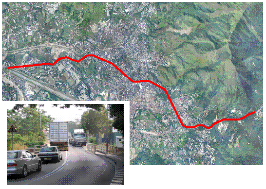
1.5
|
Figure 1.1 displays the
location of the Project. The
Project involves upgrading some 5.2 km of Kam Tin Road and Lam Kam Road to a standard width single
two-lane carriageway, including improvements to pedestrian facilities and
public transport laybys, and associated slope, drainage and landscape works.
|
|
1.6
|
The upgrade works are required
as the existing width is sub-standard, and the safety hazard to road users is
compounded by fast vehicular traffic, sharp bends, hidden accesses,
sub-standard gradients, inadequate lateral clearance, frequent usage of heavy
vehicles, insufficient pedestrian crossing facilities and lack of bus-bays.
|
|
1.7
|
Specifically, the Project is a
DP since part of the Project boundary encroaches upon Conservation Area (CA)
zoning as defined on relevant Outline
Zoning Plans (OZPs), and as referred in
Section 1.3 of the EIA Study Brief No. ESB-170/2007. There are four encroachment areas:
·
CA at north of section
between Chainage CHB 28+70 and CHB 30+10 of Kam Tin Road;
·
CA at south of section
between Chainage CHB 49+10 to CHB 52+40 of Lam Kam Road;
·
CA at south of section
between Chainage CHB 48+00 to CHB 52+30 of Lam Kam Road; and
·
CA at north of section
between Chainage CHB 50+20 to CHB 52+40 of Lam Kam Road.
|
|
1.8
|
Project construction is
scheduled to commence in the first quarter of 2011 for completion in the
third quarter of 2015. The works
shall include paving, drainage and slope works. A works method has been
devised that minimises impacts upon existing road side trees.
|
|
1.9
|
One Designated Project defined by the EIAO,
namely, Hong Kong Section of Guangzhou
- Shenzhen - Hong Kong Express Rail Link will be implemented. As the EIA study of this railway
project is in progess, there is no detailed construction methods and
programme can be reviewed. As
such, the EIA study of this railway project should take into account the
potential cumulative impacts arising from the proposed Project. Two other Designated Projects defined
by the EIAO, namely, Yuen Long, Kam
Tin, Ngau Tam Mei & Tin Shui Wai Drainage Improvement Stage 1, Phase
2B – Kam Tin Secondary Drainage Channel
KT13 (CE 67/98) and Drainage
Improvement in Sha Tin and Tai Po Design and Construction (CE 50/2001)
will be implemented. However, no
cumulative impacts are anticipated from these two projects as both are
scheduled to be completed before the commencement of the Project, and both
are located over 1 km
from the proposed Project.
|
2.0
AIR QUALITY IMPACT ASSESSMENT
Introduction
2.1
The air quality
impacts during the construction and operational phases of the Project have been
assessed and evaluated in accordance with the guidelines and criteria referred in
Annexes 12 and 4 of the EIA-TM, respectively. Reference has also been made to other
standards for the control of air pollutants from a variety of stationary and
mobile sources established under the Air Pollution Control Ordinance. Baseline
air quality conditions were derived using data from EPD’s Tai Po Air Quality Monitoring Station.
Construction
Air Quality Impact Assessment
2.2
Fugitive Dust
may be generated from works activities including site clearance, excavation,
handling of construction materials, concrete breaking and from minor wind
erosion. Due to site constraints
and necessary road traffic management arrangements, each works area and the
amount of excavated/handled materials for all work fronts is small, dust
impacts during the construction phases are anticipated to be insignificant with
the adoption of mitigation measures stipulated in the Air Pollution Control
(Construction Dust) Regulation.
2.3
In
addition, activities that may induce significant dust emissions such as
extensive site formation and blasting are not required for Project development.
2.4
Gaseous
emissions from properly maintained diesel-powered construction equipment shall
not result in any significant impact during construction.
2.5
There may
be localized dust emissions from concurrent construction activities from other
projects, but the quantity of the spoil materials from the concurrent projects
unlikely to be large enough to cause a significant dust nuisance. As such, the cumulative dust impacts as
a result of concurrent works within the study area are not expected given the large
distance separation and provided that the recommended dust suppression measures
are implemented.
2.6
Although
no adverse construction phase air quality impacts are anticipated, a number of best
practice measures have been recommended to ensure compliance with the Air
Pollution Control (Construction Dust) Regulation. It is also recommended that construction
phase EM&A is conducted as a precautionary measure to ensure no ensure
construction phase best practice measures are properly implemented and are
effective.
Operational
Air Quality Impact Assessment
2.7
The air dispersion
model CALINE4 was adopted to predict vehicle exhaust emissions from the Project
and major surrounding roads. The hourly NO2, 24-hour average NO2
and RSP concentrations at identified Air Sensitive Receivers (ASRs) were determined.
The predicted peak traffic flows in the year 2030 were adopted to represent the
worst-case scenario. The emission model EMFAC-HK was adopted to estimate the
vehicle emission factors of NOx and RSP.
2.8
All predicted 1-hour and 24-hour NO2
and 24-hour RSP levels will comply with the Air Quality Objectives (AQOs) and
hence no mitigation measures are required and no operational phase EM&A has
been recommended.
3.0
NOISE IMPACT ASSESSMENT
Introduction
3.1
Construction
and operational phase noise
impacts have been assessed and evaluated in accordance with Annexes 13 and 5 of
the EIA-TM, respectively. Noise
control is also governed by the Noise Control Ordinance (NCO) (Cap 400), with
relevant technical memoranda under the NCO for this assessment including those on Noise from Construction Work other than
Percussive Piling (GW-TM) and Noise from Construction Work in Designated Areas
(DA-TM).
3.2
Annex 5
of the EIA-TM stipulates the noise criteria to control the road traffic noise
during the Project operation.
3.3
For the
traffic noise impact assessment, the roads within 300m from the Project boundary have been included in
the assessment. Traffic noise has
been predicted for two scenarios: original scenario (maximum traffic projection without the Project) and unmitigated
scenario (maximum traffic projection with the Project.
3.4
The
traffic noise impact is significant if the following conditions are met:
·
Predicted
unmitigated traffic noise level (i.e., “Unmitigated Scenario”) at the
representative NSRs exceeds the noise criteria by 1.0 dB(A) or more; and
·
Predicted
unmitigated traffic noise level at the representative NSRs with the Project is
greater than that without the Project (i.e., “Original Scenario”) by 1.0 dB(A)
or more.
3.5
If any of
the NSR cannot be protected by the recommended direction noise mitigation
measures, indirect technical remedies for those NSR may be adopted.
Construction
Noise Impact Assessment
3.6
The use
of Powered Mechanical Equipment (PME) in daytime is expected to be the major
noise source during the construction of the Project. There shall be no percussive piling
works within the project area, and no works are scheduled during noise control
restricted hours.
3.7
The
construction noise impact at representative NSRs has been conducted using an
assumed PME inventory. The Project
Proponent confirmed that the PME inventory list is practicable and practical to
complete the works within scheduled timeframe and are available in Hong Kong.
3.8
The
assessment results indicate adverse noise impacts are anticipated at most of
the representative NSRs and and noise mitigation measures will be required to
reduce the construction noise impact to acceptable levels. Mitigation measures including good site
practices, the use of quieter PME, avoidance of concurrent construction
activities, installation of acoustic enclosure and erection of temporary noise
barriers shall be necessary to reduce noise to an acceptable level.
3.9
Due to
the proximity of some NSRs to the construction work, noise exceedances of
relevant standard at several NSRs are expected even after all practical noise
mitigation measures have been exhausted to minimise the noise impacts. Unavoidable residual impacts are
predicated at six NSRs, namely N6, N7, N13, N19, N27 and N39. The exceedance of 1 to 9 dB(A) above the noise criteria are mainly
contributed due to the road paving work. The expected exceedance
periods at each respective sites are less than 6 working days (road upgrading
work) and 2 working days (road paving work) respectively.
3.10
It is
recommended that more detailed construction work programme should be
established by the Contractor before actual construction work and applicable
noise mitigation measures should be implemented according to the actual site
condition and constraints in order to minimize the potential construction noise
impact.
3.11
No cumulative
construction noise impacts are anticipated due to optimal Project scheduling,
and due to the nature and distance separation of other construction projects. Although all practical effective noise
mitigation measures have been fully explored and exhausted to minimize the residual
impact arising from the construction works, it is anticipated that there will
be potential adverse noise impacts during construction. Therefore, environmental monitoring and
audit is proposed to ensure the recommended mitigation measures are effectively
implemented.
Operational Noise Impact Assessment
3.12
Traffic
noise levels at representative NSRs were predicted using the roadNoise model, based
on the peak hour traffic flow of year 2030 adopted for the assessment. The traffic speed for all roads
including Kam Tin Road
and Lam Kam Road
used in the model is 50 km/hour
and a section of Kam Tin Bypass is 70 km/hour. All major roads within 300m of the Project area have been
included in the assessment.
3.13
The
predicted traffic noise contribution due to the proposed Project is less than
1.0 dB(A), the traffic noise impact from the Project is considered not
significant. Hence, direct noise
mitigation measures are not considered necessary during the operation phase.
4.0
WATER QUALITY IMPACT ASSESSMENT
Introduction
4.1
The water
quality assessment and evaluation has been conducted in accordance with the guidelines
and criteria as presented in Annexes 14 and 6 of the EIA-TM, respectively.
4.2
The
relevant primary legislation is the Water Pollution Control Ordinance (Cap.
358), the associated Technical Memorandum on Standards for Effluents Discharged
into Drainage and Sewerage Systems, Inland and Coastal Waters; and the Water
Quality Objectives (WQOs) for the Deep Bay Water Control Zone (WCZ) and the
Tolo Harbour Supplementary WCZ.
4.3
Water
courses within the project area comprise the channelized Kam Tin River and a number of natural streams near
Kadoorie Experimental Farm, Ling Wan Monastery, Wong Chuk Yuen, Sheung Tsuen
and Kam Tin Bypass with unpolluted and polluted sections. The Project falls
within two water control zones, with the Kam
Tin River
and its tributaries carrying waters generally polluted by organic pollution to
the west towards Inner Deep Bay,
and with the clean tributaries of the Lam
Tsuen River
flowing west towards Tolo
Harbour. It is noted that there is an
encroachment of about 60m of the water gathering zone located at the eastern
end of the Project.
4.4
These
observations are consistent with EPD’s latest water quality index classifying Lam Tsuen River as “excellent” but Kam Tin River as “bad” or “very bad” in 2006. Overall compliance with WQOs for Kam Tin River and Lam
Tsuen River
is 39% and 95%, respectively, although implementation of the Yuen Long & Kam
Tin Sewerage Master Plan is expected to gradually improve the situation.
Construction Phase Impact Assessment
4.5
Potential
water quality impacts may arise from general road construction works and
associated facilities. Key sources of impact may include:
·
Surface runoff from
rainfall and wind erosion of exposed surface areas, and material stockpiles and
vehicle wheel washing facilities;
·
Wash water from
dust suppression measures;
·
Spillage of
chemicals, lubrication oils, solvent and petroleum products; and
·
Sewage from the
construction workforce.
4.6
In
particular, surface run-off into receiving water courses during and immediately
after rainstorm events is a concern. Sediment laden run-off would result in
deteriorating water quality and may result in induced effects on aquatic
ecological resources. However, given both the magnitude and duration of works
it is anticipated that unacceptable water quality impacts can be avoided with
the proper implementation of appropriate construction run-off management
practices referred in ProPECC PN 1/94 Construction Site Drainage. Regular site
inspections are recommended during construction to ensure the mitigation
measures are implemented properly.
4.7
Domestic
sewage generated by the construction workforce shall be appropriately managed
to avoid the potential adverse impacts of uncontrolled sewage discharge into
nearby water courses. Portable chemical toilets shall be appropriately located
on site in proximity to all key works areas where they shall remain and be
maintained in good working order for the convenience of the workforce for the
duration of the works.
4.8
Concurrent
projects are distant from the proposed Project area, and hence no significant
cumulative impacts are anticipated.
4.9
As the
Project boundary fall within about 60m of the water gathering grounds located
at the eastern end of the Project, the water pollution control measures should
be implemented. In addition, the
Project should not have any permanent adverse effect on the gathering ground
and the such measures in place, the water quality impact during the Project
construction is considered insignificant.
Operational Phase Impact Assessment
4.10
Potential
water quality impacts during the operational phase may arise from highway
discharge. Material deposited and accumulated on the road surface, including
dust / sediment, heavy metals and vehicle oil, will be washed from the
carriageway during rainfall events into silt traps and the existing / proposed
drainage system.
4.11
Given the
negligible change in the forecast traffic volume and composition, the nature
and volume of highway discharge will not significantly increase during Project
operation, no adverse impacts are anticipated.
5.0
WASTE MANAGEMENT
Introduction
5.1
The criteria
and guidelines for evaluating and assessing waste management implications are
set out in Annex 7 and Annex 15 of the EIA-TM. Reference has also been made to the
Waste Disposal Ordinance (Cap. 354) and subsidiary legislation, and relevant
circulars issued by ETWB and the Works Bureau.
5.2
“Guidance Note for
Contaminated Land Assessment and Remediation” and “Guidance Notes for
Investigation and Remediation of Contaminated Sites of Petrol Filling Stations,
Boatyards and Car Repair /Dismantling Workshop” issued by EPD provides guidance
on land contamination assessment.
Waste Impact Assessment
5.3
The following
types of wastes are anticipated during the construction of the Project: construction
and demolition (C&D) material; chemical wastes, and general refuse.
5.4
C&D
material would be generated from the road upgrading works, associated slope and
landscaping works on Kam Tin Road
and Lam Kam Road
during the course of the works between Year 2010 and 2015. The types of C&D material during the
construction works would be soil, fill and artificial hard materials (e.g.
concrete/bituminous pavement). It
is estimated that the total volume of the C&D material generated from the
Project would be approximately 45,000m3.
5.5
All C&D materials generated shall be sorted
on site into inert portion “inert C&D materials” including soil, building
debris, broken rock, concrete, etc., and the non-inert portion is the
"C&D wastes" comprising timber, paper, plastics, general refuse
etc. The inert C&D materials,
the reusable and/or recyclable materials shall be recovered before disposal of
the waste portion off site as a last resort. The waste portion of the inert
C&D materials may be disposed of at the public fill reception facility at
Tuen Mun Area 38, and the C&D wastes at North East New Territories (NENT)
Landfill in Ta Kwu Ling. The estimated amount of C&D waste to be
disposed of landfill and public filling reception facility would be 2,000m3
and 20,000m3 respectively.
5.6
Methods to
minimise the generation of C&D material will be addressed during detail
design and in planning of the construction works. A Waste Management System will be
incorporated into the Waste Management Plan (WMP) to effectively manage and
avoid/reduce/minimise the generation of C&D material during construction.
5.7
To prevent
fly-tipping of C&D materials, a Trip Ticket System will be implemented to
monitor C&D wastes from the Project, a truck carrying debris should first
obtain a ticket on leaving the construction site, then dump the debris at the
designated location and finally have the ticket stamped and returned to the
construction site.
5.8
Construction
plant and vehicle maintenance may generate a small amount of chemical wastes
during construction works, such as cleaning fluids, solvents, lubrication oil
and fuel. However, the volume of chemical waste shall be limited and is anticipated
to be no more than a few cubic metres per month. The volume of chemical waste
generated shall be quantified in the Waste Management Plan to be maintained by
the Contractor.
5.9
Materials
classified as chemical wastes will require special handling and storage
arrangements before removal for appropriate treatment at the Chemical Waste
Treatment Facility (CWTF) or other licensed facilities. Wherever possible opportunities should
be taken to reuse and recycle materials.
5.10
The workforce
would generate refuse comprising food scraps, waste paper, empty containers,
etc. Such refuse will be collected
on-site for disposal at an approved facility. Effective collection of site
wastes will prevent waste materials being blown around by wind, or creating an
odour nuisance or pest and vermin problem.
Waste storage areas will be well maintained and cleaned regularly.
5.11
The maximum
number of construction workers to be employed is estimated to be about 80
workers. Based on a generation rate
of 0.65 kg per worker
per day, the maximum daily arising of general refuse during the construction
period would be approximately 52 kg
and this waste can be effectively controlled by normal measures. With the implementation of good waste
management practices at the site, adverse environmental impacts are not
expected to arise from the storage, handling and transportation of workforce
wastes.
5.12
As a best
practice measure it is proposed that regular site inspections and audits of
construction phase waste management be undertaken as part of a broader
construction phase EM&A programme.
Land Contamination Impact Assessment
5.13
In order to
identify and evaluate the potential contamination impacts associated with
Project development, a desktop study has been undertaken to review current and
historical land uses and site inspection has been undertaken to confirm
existing land uses. A review of applicable aerial photographs has also been
conducted.
5.14
Land around Lam Kam Road is mainly
undeveloped area, while Kam Tin
Road is mainly surrounded by barracks, village
houses and open space. Some car repair
workshops and petrol filling stations were also found along Kam Tin Road and Lam Kam Road which may potentially be
existed contaminated soil.
5.15 As there could be possibilities of land contamination
at the Project area adjacent to the car repairing workshops, a further land
contamination investigation shall be carried out at these sites to identify the
possible land contamination at these locations.
5.16 With the
implementation of the recommended mitigation measures for the handling of any
contaminated materials, no adverse environmental impacts on land contamination
for the Project are anticipated.
6.0
ECOLOGY IMPACT ASSESSMENT
Introduction
6.1
This section
summarises the approach to and the findings of the ecological baseline survey
and impact assessment. Key criteria
for baseline evaluation and impact evaluation are presented in Annex 8 of the
EIA-TM. Reference has also been
made to various other legislation and standards for impact assessment and
evaluation, including inter alia the Wild Animals Protection Ordinance (Cap.
170) and the Protection of Endangered Species of Animals and Plants Ordinance
(Cap. 586).
6.2
The ecological
assessment area for the purpose of terrestrial ecological assessment shall
include all areas within 500 metres from the Project site boundary and the
areas likely to be impacted by the Project. For aquatic ecology, the Assessment Area
(Study Area) shall be the same as the water quality impact assessment, i.e. all
aquatic areas within 300 metres from the Project site boundary.
6.3
A desk-top
study of ecological resources was undertaken to guide survey methodologies and
fieldwork locations for habitat mapping and surveys of vegetation, birds,
invertebrates, stream fauna, herpetofauna and mammals. It was determined that over 65% of the
terrestrial study area is occupied by urbanised / disturbed, with the remainder
mainly comprising secondary woodland and (largely abandoned) agricultural land.
6.4
Species of
conservation concern observed in the survey area in the past and / or through
the 2008 field survey included a variety of bird and herpetofauna species. While the broader study area is diverse,
areas close to the existing road / developed area are highly disturbed. Full details of the ecological baseline
review are presented in the EIA Study Report.
Construction Phase Impact
Assessment
6.5
Project
construction activities shall include inter alia site clearance, cut and fill
slope works alongside Lam Kam Road
and Kam Tin Road,
and paving. Potential impacts due
to proposed construction shall include: vegetation clearance / habitat loss and
wildlife disturbance.
6.6
Some 6.6
hectares of land will be required for the proposed Project development, mostly
comprising 5.3 ha
of urbanized / disturbed land.
There shall also be a loss of 0.76
ha secondary woodland (almost all of which is under
Conservation Area zoning) and 0.5
ha of agricultural land, approximately 117m2
of the periphery of a meander and approximately 208m2 of a drainage channel. As most of the affected habitat is
disturbed areas dominated by common tree plantings, ornamental plantings and
weeds. The secondary woodland affected is entirely associated with engineered
slopes of occasionally moderate baseline value. Overall, the construction phase impacts
due to habitat loss / vegetation clearance are anticipated to be low and shall
be mitigated through compensatory planting.
6.7
Precautionary
measures to avoid unnecessary impacts on natural stream courses and/ or nearby
vegetation during construction phase shall be implemented, including proper
temporary cover of stored construction materials, and storage away from
streams. Protection measures shall be implemented to avoid any possible
construction impacts upon the fruit bat roost in the Chinese Fan-palm on Lam Kam Road,
including establishment of a Tree Protection Zone.
6.8
During
construction activities the potential exists for visual and noise disturbance
upon wildlife. However, such
impacts are not anticipated to be significant given the large contiguous area
of existing undisturbed secondary woodland and lowland stream course habitat
that wildlife will already preferentially utilize.
6.9
Ecological
monitoring is not considered necessary, although regular construction phase
site inspections are recommended to ensure proper implementation of mitigation
measures.
Operational Phase Impact Assessment
6.10
Road traffic is
the only possible resultant disturbance to the nearby wildlife during project
operation. Due to close proximity
to road traffic and the existing (high) level of disturbance along the roadside,
wildlife of conservation concern prefer to frequent areas distant from the
roadside. As such, no significant
disturbance impacts are anticipated.
7.0
CULTURAL HERITAGE IMPACT ASSESSMENT
Introduction
7.1
As stated in
the project Study Brief any negative impacts to any identified Sites of
Cultural Heritage should be identified for both the construction and
operational phases of the project and measures should be proposed to mitigate
any such identified impacts.
7.2
The Antiquities
and Monuments Ordinance provides the statutory framework for the preservation
of objects of historical, archaeological and palaeontological interest,
including the statutory procedures for the Declaration of Monuments. Also relevant are the EIA-TM and Chapter
10 of the Hong Kong Planning Standards and Guidelines.
Archaeology Impact Assessment
7.3
There is one Site
of Cultural Heritage in the project Study Area, the Pat Heung Sheung Tsuen
Archaeological Site (AM04-2022). The site was originally identified as part of
a survey undertaken in the area in 1999 when field testing was conducted and a
total of 60 sherds (celadon and white porcelain) dating from the Song Dynasty
were recovered. Based upon, the type, nature and quality of the finds it was
postulated that Pat Heung Sheung Tsuen was a residential site dating from the
Song period (HKIA 1999).
7.4
As the Project works
will be limited to areas immediately adjacent to the existing road, existing
impacts from underground utilities and previously undertaken road works make it
unlikely for undisturbed archaeological deposits to be present. This, however,
does not preclude the existence of isolated or disturbed archaeological
material to exist within the proposed works areas. However, as the previous
disturbances to the area will limit the information that can be obtained from
any archaeological material that may still exist within the project study area,
no further investigation is recommended.
7.5
As
precautionary measures, should the contractor identify any antiquity or
supposed antiquity during the course of the excavation works then the
Antiquities and Monuments Office must be informed immediately. The project proponent shall take all
necessary archaeological mitigation measures to preserve the antiquities.
7.6
Field surveys
undertaken during 1999 archaeological investigations (ERM 1999; HKIA 1999) did
not identify any areas of archaeological potential outside of the Pat Heung
Sheung Tsuen Archaeological Site in the Study Area. As such, no further
investigation of alignment sections outside the archaeological site is
recommended. However, as precautionary measures should the contractor identify
any antiquity or supposed antiquity during the course of the excavation works
then the Antiquities and Monuments Office must be informed immediately. The project proponent shall take all
necessary archaeological mitigation measures to preserve the antiquities.
7.7
Regarding the Lam Kam Road
sections of the alignment, these are situated on steep hillsides running from
approximately 50 mPD to 180 mPD in an area containing granite outcrops and
characterised by debris flow deposits.
As such, the area does not have the potential to contain archaeological
deposits and no further investigation is recommended. . However, as
precautionary measures should the contractor identify any antiquity or supposed
antiquity during the course of the excavation works then the Antiquities and
Monuments Office must be informed immediately. The project proponent shall take all
necessary archaeological mitigation measures to preserve the antiquities.
Built
Heritage Impact Assessment
7.8
Although the
desk-based study did not reveal the presence of any built heritage resources
that could qualify as Sites of Cultural Heritage, a site visit was undertaken
to confirm that no such sites with the potential to qualify as such were
present in the project study area. The site visit confirmed that the Study Area
does not contain any Sites of Built
Cultural Heritage.
8.0
LANDSCAPE AND VISUAL IMPACT ASSESSMENT
8.1
This section
summarises the approach to and the findings of the Landscape and Visual Impact
Assessment. The key criteria for landscape and visual baseline study and impact
assessment are presented in Annexes 10 and 18 of the EIA-TM. In addition the assessment report makes
reference to other relevant legislation and standards for impact assessment and
evaluation.
8.2
The Study Area
for the preparation of the landscape impact assessment was to include all areas
within 500 metres from the Project site boundary and the areas likely to be
impacted by the Project. For the
visual impact assessment the Study Area is based on the visual envelope, the
area from which the proposals can be seen.
8.3
Landscape
mitigation measures have been recommended to ameliorate the potential landscape
and visual impacts, and ensure that upon implementation the Project will fit
into the existing landscape and visual context. These measures include the
careful design of the engineering
measures to minimize the potential impacts upon the existing landscape
resources within the road corridor and the visual amenity for both nearby
residents and vehicle travellers and pedestrians. This includes the existing
trees which line the road and are important to both the landscape context of
the road corridor and in screening the road in views from adjacent VSRs.
Another important aspect of the landscape mitigation approach is the planting
of new trees and shrubs utilizing native species where possible to restore and
enhance the landscape setting and visual amenity of the road and its ecological
value.
No Impact on Planning and Development Control
Framework
8.4
The proposed
works will encroach upon the land use zonings discussed in the LVIA including
for example the area zoned conservation area (CA) and the loss of some Open
Space (OS) adjacent to the road. Other impacts include the loss of Government /
Institutional / Community (GI/C), Industrial (Group D) (I(D)), some loss of
Residential (Group D) and Village
Type Development (V) although these are considered to be less significant from
a landscape and visual perspective. While there may be some conflict between
the Project and the future landscape planning framework as represented by the
OZPs these impacts affect small areas of the identified zonings along the
length of the proposed scheme. Therefore it is considered that given the nature
of the impacts the scheme fits within the future landscape and visual context
although further review to the published land use plans shall be considered.
8.5
Given the above
the proposed upgrading of Kam Tin and Lam
Kam Road largely fits into the planning and
development control framework and integrates with the future outlook of the
rural landscape context. The proposed upgraded road will be gazetted under
Roads (Works, Use and Compensation) Ordinance (Cap. 370) and hence some zoning
boundaries affected by the works should be revised.
Landscape Impacts
Preservation of Existing Trees
8.6
Although the
detailed design of the proposed works is not yet available, the numbers of
trees to be retained, transplanted and removed have been estimated based on the
preliminary design. The estimated numbers will be updated in the tree removal
application to be prepared and submitted to the Lands Department for approval
in the detailed design stage in accordance with ETWB TCW No. 3/2006, ‘Tree
Preservation’.
8.7
Based on the
findings of the preliminary tree survey approximately 1,286 trees surveyed
within the proposed works boundary will be preserved in-situ and a further 6
trees by transplantation to a new location within the Site out of total 1763
existing trees. The design of the proposed engineering works has been carefully
considered to retain as many of the existing trees in-situ as possible. Where
trees have found to be in conflict with the works transplantation has been
considered. The affected trees are largely non-native plantation species
originally planted in the roadside amenity areas. Many of these existing trees
have a poor form and condition which may be due to their growth in sloping
conditions and the proximity of the trees to one another. The adoption of the
revised scheme for Option B would allow the preservation of a further 46 trees
including 224 number trees with a trunk diameter of larger than 500mm.
8.8
This tree loss
will be compensated to an extent through the planting and growth to maturity of
some 559 specimen trees at the edge of the widened carriageway to recreate the
avenue effect created by the original planting of Melaleuca quinquenervia. In
addition the proposals include the planting of some 3,031m2 of mass woodland planting (approximately 335
number trees based on planting centres of 3.5m). This would form part of the restoration and
enhancement of the areas affected by the proposed works and the infill planting
of existing areas with intermittent tree coverage. Slopes with a gradient of
steeper than 30 degrees would be hydroseeded with a native tree and shrub
planting mix. Given the predicted felling of some 431 trees the proposed planting
of 559 trees will compensate for the loss at a ratio of 1:1.3 (trees removed :
trees planted).
Preservation of Landscape
Resources
8.9
As the proposed
works are limited to the existing road corridor, the predicted residual impacts
on the majority of the landscape resources within the Study Area will be slight
to negligible within the construction phase and Day 1 and mitigated to
negligible as the works at Year 10 as the mitigation measures mature. These
include LR6 Developed Rural Land Areas, LR7 Grassland / Shrubland Mosaic, LR8
Modified Watercourse and LR9 Open Spaces and Sports Fields. There would be
moderate to slight adverse impacts for LR1 Major Road, LR3 Roadside Plantation,
LR4 Village Settlement and LR5 Hillside Mixed Woodland during the construction
phase and at Day 1 although these impacts would be mitigated to slight adverse
at Year 10. The loss of LR2 Agricultural Fields would be slight adverse both in
the construction and operational stages of the project.
Maintenance of Landscape Character
8.10
The proposed
upgrading works will take place within a Study Area characterised by an
existing tree lined road corridor containing relatively extensive engineering
works and lined by areas of dense village development, with intermittent areas
of open storage and light industrial uses. The proposals have sought to
preserve and where possible enhance the landscape character of the road
corridor through the careful design (and implementation) of the upgrading
proposals. This includes the preservation of existing trees, the proposed
planting of new tree and shrub areas and the design of new engineering
structures designed to have an enhanced aesthetic appearance compared to the
existing structures. With this approach to the design of the upgrading proposals
and the adoption of landscape and visual mitigation measures the impacts LCA4
Shek Kong Barracks, LCA5 Wang Toi Shan Village, LCA6 Kam Tin Modified Water
Course Landscape, LCA7 Shek Kong Lowland Rural Landscape, LCA8 Lam Tsuen
Country Park Hillside Landscape and LCA 9 Sheung Tsuen Lowland Rural Landscape
would be slight adverse during the construction and operational stages of the
project due to the physical loss of area.
8.11
The potential
impacts on LCA1, Tsat Sing Kong Lowland Rural Landscape, LCA3 Kam Tin Rural
Landscape and LCA11 Kwun Yam Shan Miscellaneous Rural Fringe Landscape would be
negligible due to the distance from the proposed scheme. The predicted impacts
on LCA2 Pang Ka Tsuen Lowland Rural and Low-rise Residential Landscape would in
the construction stage and at Day 1 be slight adverse however this impact would
be mitigated to negligible at Year 10 with the growth to maturity of the
proposed mitigation planting.
8.12
The predicted
impacts on LCA10 Shek Kong Barracks Landscape (Shek Kong Tsuen) would be slight
during construction stage as the works area due the proximity of the proposed
works. These impacts would become negligible during the operational stage when
the recommended landscape and visual mitigation measures are fully established.
The predicted impacts on LCA12 Kwun Yam Shan Upland and Hillside Landscape
would be moderate during construction stage and slight during the operational
stage due to the proposed mitigation measures.
8.13
The potential impacts on LCA13 Kam Tin Road
and Lam Kam Road Corridor would
be significant during construction stage due to the direct impacts along the
full length of the road due to the upgrading works. With the implementation of
the mitigation measures including the proposed roadside tree planting these
impacts would be reduced to moderate adverse during the operational phase of
the project.
Visual Impacts
8.14
Given the scale
and nature of the Project, and the quality and extent of existing views the
adjacent VSRs would be subject to a slight to moderate adverse visual impact.
Factors influencing the level of predicted impact include the nature of the
existing road corridor and engineering works, the quality of the existing
visual amenity and the density of the existing villages; and the enclosure
formed by the adjacent development and the preserved trees. In addition it
should be noted that for many of the villages the views would only be available
from properties on the periphery of the settlement. Views from the inner most
houses would be blocked by the properties and vegetation at the edge of the
village settlements. The main impacts would be experienced by two key groups.
The first would be the vehicle travellers and pedestrians using the road
alignment and the second the residential properties adjacent to the main
engineering works. These works include the widening of the bridge and the
proposed cuttings and extensions to the existing embankments.
8.15
For vehicle travellers and pedestrians (except
VSRs 2 Vehicle Travellers on Kam Tin Road to the north of Shek Kong Barracks
(east bound) and VSRs 3 Pedestrians on Kam Tin Road to the north of Shek Kong
Barracks, VSR 14 Vehicle
Travellers on Kam Tin Road to the south of Wang Toi Shan Ho Lik Pui (eastbound)
and VSR 15 Pedestrians on Kam Tin Road to the north of Shek Kong) would have the ‘moderate’ mitigated impacts during
the operational phase at Day 1 and the residual impacts during the Year 10
(when the tree and shrub planting has matured) would be slight due to the
extent of the works. Although the mitigation measures would realise some
improvement and softening of the proposals the impacts would persist. However
it should be remembered that the visual amenity for these VSRs is already
characterized by the structures associated with the existing road corridor and
so any changes to the visual amenity will not be significant. For vehicle
travellers and pedestrians on Lam
Kam Road the impacts during the design year would
be mitigated from moderate to slight adverse due to the proposed tree and shrub
planting proposed for the extension to the cuttings and embankments.
8.16
For the
residential VSRs the predicted unmitigated and mitigated impacts for VSR 1: Residents of Kiu Tau Tsuen, VSR4: Residents of Pang Ka Tsuen, VSR6:
Residents of Shek Kong San Tsuen, VSR7: Residents of Seasons Villas, VSR9:
Residents of Leung Uk Tsuen, VSR11: Residents of Wang Toi Shan Yau Uk Tsuen,
VSR12: Residents of Wang Toi Shan Lo Uk
Tsuen; VSR13: Residents of Wang Toi Shan San Tsuen; VSR16: Residents of Wang
Toi Shan Ho Lik Pui; VSR18:Residents of Pine Hill Villa; VSR19: Residents of Cheung Uk Tsuen; VSR20: Residents of Sheung Tsuen San Tsuen; VSR22:
Residents of Wong Chuk Yuen; VSR23: Residents of Shek Kong Village; and VSR24:
Residents of Lui Kung Tin would be moderate during the construction and operational
phases of the project. It should be noted that these impacts represent the
worst case scenario for these VSR’s located at the edge of the settlements and
that their existing views are characterised by Kam Tin and Lam Kam Roads. For
residents of VSR 31 Residents of Western Leung Uk Tsuen the initial moderate
adverse impacts predicted for the construction phase and at Day 1 would be
mitigated to slight adverse by Year 10 as the proposed tree planting screening
the bridge approach road matures.
8.17
It should be
noted that the majority of the residential VSRs the existing views are partial
or glimpsed due to the screening effect of the existing landform, roadside
vegetation, and the vegetation associated with individual settlements, and
existing built development. Further views of the road corridor are largely
limited to residences on periphery of the existing settlements with views for
the houses beyond screened due to the density of the existing development and
the relatively flat topography of the inhabited areas. Given the restricted
nature of these views and hence visual access to the scheme proposals the level
of the predicted impacts derives more from the nature and sensitivity of the
residential VSR than the magnitude of change arising from the proposals which
would be apparent in these views.
8.18
For the other
VSRs namely the occupational, trail walkers and recreational users of the open
space the predicted impacts during the construction phase Day 1 and Year 10
would be slight adverse to negligible. This is due to the restricted nature of
the upgrading proposals and roadside character of the existing views, and the
small part of the scheme proposals which would be visible to them.
8.19
Therefore it is
considered that upon the growth to maturity of the proposed compensatory and
mitigation planting and restoration of disturbed areas, the widening proposals
will not constitute a significant component in available views and that the
Project can be successfully integrated within the existing landscape and visual
context.
Residual Impacts
8.20
Although the
proposed upgrading of Kam Tin and Lam Kam Roads will have some slight to
moderate residual impacts locally to the areas adjacent to the proposed works,
mainly due to tree loss and the appearance of engineered structures upon the
full establishment of landscape and visual mitigation measures, and with
consideration of the restricted nature of existing views it is considered that
the impacts will be largely mitigated. Therefore in accordance with Annex 10,
Paragraph 1.1(c) of the EIAO TM, the landscape and visual impacts of the
proposed works would be ‘acceptable with mitigation’ (following the growth to
maturity of the proposed tree planting 10 to 15 years following the completion
of the construction phase of the project) that is to say ‘there would be some
adverse effects, but these can be eliminated, reduced or offset to a large
extent by specific measures.
9.0
CONCLUSIONS
9.1
Environmental
impacts associated with the proposed Project during the construction and operational
phases have been summarized in this report, and mitigation measures have been
proposed to reduce impacts to an acceptable level as necessary and supported by
a programme of environmental monitoring and audit if appropriate.
9.2
The major
conclusions of the environmental study are summarized below.
Air Quality
Impacts
9.3
Due to
the small amount of dust emissions from the active construction site, the dust
impacts arising during the construction phase have been anticipated to be
insignificant with the implementation of the dust suppression measures
stipulated in the Air Pollution Control (Construction Dust) Regulation.
EM&A is required to ensure proper implementation of the dust suppression
measures.
9.4
According
to the model predictions, no adverse air quality impact on the identified ASRs
is expected from the traffic emissions.
Noise
Impacts
9.5
Construction
noise from the powered mechanical equipment (PME) has been predicted to cause
adverse impacts on the identified NSRs due to the close proximity of these NSRs
to the noisy plants. Mitigation measures such as quiet PME and temporary noise
barrier/screen have been proposed to reduce the noise impacts. Residual impacts
on some NSRs would be anticipated. Construction EM&A is recommended.
9.6
During
the operational phase, no significant difference of the traffic noise impacts
before and after the proposed Project has been predicted. No direct mitigation
measure is required to reduce the traffic noise impacts.
Water
Quality Impacts
9.7
With the
implementation of the recommended mitigation measure such as control measures
on the surface runoff and drainage from the works area, proper site management
and good housekeeping practices, no adverse water quality impact on the
receiving in-land water bodies has been anticipated during the construction
phase. Routine site inspection during construction phase is recommended.
Waste Implications
9.8
With
proper handling, transport and disposal of waste using the recommended good
management and site practices, no significant environmental impacts during the
construction phase has been expected. It is the contractor’s responsibility to
ensure that these practices and the mentioned Regulations and EPD’s requirement
are implemented in order to manage the wastes generated from the site properly.
Regular site inspections of the waste management during the construction phase
are recommended.
9.9
The
potential land contamination issues can be adequately controlled with suitably
planned construction and works in accordance with the remediation action plan
and the recommended precautionary protection measures for workers.
Ecology
9.10
Most of
the immediate study area is occupied by
urbanised / disturbed, with the remainder mainly comprising plantation
secondary woodland and largely abandoned agricultural land. However there are
undisturbed areas remote from the roadside where wildlife exists.
9.11
The main
construction phase impact is associated with site clearance and geotechnical
works, resulting in tree felling and removal of ground vegetation. These activities will primarily affect
urbanized / disturbed land, but also some 0.76 hectares of secondary woodland
dominated by common trees on engineered slopes, approximately 117m2
of the periphery of a meander and approximately 208m2 of a drainage channel. Site inspections are proposed to ensure mitigation measures are properly
implemented.
9.12
Due to
close proximity to road traffic and the existing road traffic disturbance along
the roadside, wildlife of conservation concern prefer to frequent areas distant
from the roadside. As such, no
significant disturbance impacts are anticipated.
Landscape and Visual Impact
9.13
Given the
nature of the proposed project and the full implementation of the proposed
mitigation measures the potential residual landscape and visual impacts will
not be significant and will be acceptable after mitigation. The proposals will
take place within an existing road corridor and so impacts to landscape
resources and the landscape character of the area will be limited. The main
mitigation measures include the (i) preservation, where possible, of existing
trees; (ii) the aesthetic consideration of the appearance of the main
engineering structures and (iii) the planting of new native trees and shrubs in
roadside areas. These planting proposals are designed to restore and enhance
the landscape setting and visual amenity of the road and its ecological value.
9.14
In total of 1763 existing trees, 1286 trees will be preserved in-situ and 6 trees will
be transplanted to new locations within the road corridor. The affected trees
are largely exotic, plantation species with many exhibiting a poor form and
health condition. The compensatory planting proposals include some 559 specimen standard sized trees and 3,031m2 of
mass woodland planting using light standard sized trees to compensate for the
loss of existing trees and enhance the landscape and visual amenity of the road
corridor.
9.15
The residual
impacts on most landscape resources will largely be slight adverse to
negligible during Year 10 of the Operational Phase of the project. Impacts on
the existing landscape character will be slight adverse to negligible due to
the existing character of the road corridor and the enclosure provided by
existing roadside trees and buildings and the growth to maturity of the
proposed mitigation planting. The residual impacts for residential properties
within the villages which line the route alignment would be moderate during
Year 10. However it should be noted that the majority of the existing views
residential VSRs are partial or glimpsed due to the screening effect of the
existing landform, roadside vegetation, and the vegetation associated with
individual settlements, and existing built development. Further views of the
road corridor are largely limited to residences on periphery of the existing
settlements with views for the houses beyond screened due to the density of the
existing development and the relatively flat topography of the inhabited areas.
9.16
Predicted
visual impacts for the vehicle travellers and pedestrians on Kam Tin and Lam
Kam Roads will not be significant during Year 10,impacts will
range from moderate to slight adverse when the proposed mitigation planting is
fully established. In addition the existing views available to these VSRs are
characterised by existing road and its associated structures and so the future
view will not be significantly different.
9.17
For
the other VSRs namely the occupational, trail walkers and recreational users of
the open space the predicted impacts during the construction phase Day 1 and
Year 10 would be slight adverse to negligible due to the restricted nature of
the upgrading proposals and roadside character of the existing views, and the
small part of the scheme proposals which would be visible to them.
9.18
Therefore upon
the establishment of proposed compensatory planting and restoration of disturbed
areas, the widening proposals will not constitute a significant component and
that the Project can be successfully integrated within the existing landscape
and visual context.
Cultural Heritage Impacts
9.19
The proposed
works have the potential to impact on isolated and/ or disturbed archaeological
material and as precautionary measures should the contractor identify any
antiquity or supposed antiquity during the course of the excavation works then
the Antiquities and Monuments Office must be informed immediately. The project proponent shall take all
necessary archaeological mitigation measures to preserve the antiquities.’
9.20
No
adverse impacts to Sites of Built Cultural Heritage will arise from the project
and no mitigation measures will be required for either the construction or
operational phases.